Responsive Roadways

We have built a prototype infrastructure for the real-time collection
and distribution of comprehensive information about road traffic and conditions
on a network of streets. Small (2 cm diameter) cylinders placed just under
the road surface count passing vehicles by detecting magnetic-field disturbances.
Periodically, these sensors transmit an updated count by radio to a regional
repeater, which relays them to a central processing station. The package,
powered by a single lithium battery, costs about $40, and can be installed
in a few minutes without tearing up the road.
The central station uses the sensor data to compute queue-length and departure rate statistics for each road segment, and uses Little's Formula to assign a time in seconds to each road link. This database is published once a minute on the Internet. Vehicles will use CDPD or a similar wireless network standard to download the relevant sections of the database, and plan optimum (shortest time or least fuel) routes through the road network, informing the driver of suggested route changes in real time. We have also explored adding other minimally expensive sensors to this package, such as piezo pickups for detecting road vibration and perhaps accident signatures, and temperature and humidity sensors to determine local road conditions.
Photographs and Images Relating to this Project:
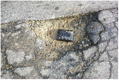
The final prototype
used in our road tests (in the photograph above, it can be seen sitting
in a pothole in Vassar Street where the data was collected, mounted in
its protective Delron case)
An earlier prototype circuit for the RF and data collection sections
Car-counting data wirelessly uploaded from the above Vassar St. pothole, showing traffic building during the morning Cambridge rush hour, then abrubtly slowing as a traffic jam developed at peak commuting time (8 AM).
The car-sensing roadstud recently designed by VehicleSense, an MIT startup inspired by this project.
The above roadstud being inserted in a hole in the Main Street pavement for a testing run.
More Information on this System:
A brief presentation given at the Media Lab's CC++ Consortium Meeting in the fall of 2000.
Ara's M.Eng. thesis:
A
Wireless Sensor Network for Smart Roadbeds and Intelligent Transportation
Systems, Ara N. Knaian, M. Eng. Thesis, MIT EECS Department and The
MIT Media Lab, June 2000.
Return to the Responsive Environments Group Projects Page

Joe Paradiso
